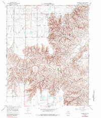
1966 Map of Bowers City
USGS Topo · Published 1984About this map
Bowers City serves as a focal point in this 1966 topographic survey of Gray County, situated amidst a landscape heavily defined by the energy industry. The extensive Gas and Oil Field dominates the terrain, punctuated by infrastructure including a refinery, Pumping Sta, and various Radio Towers. This industrial footprint is integrated into a geography carved by the North Fork Red River and Grandview Creek, where the sharp relief of the river breaks contrasts with the flatter tablelands to the north and south.
Find a feature on this map
11 named features on this map. Tap any name to fly to it.
Don’t see what you’re looking for? This feature index may not catch every label — zoom into the map to look around manually.
Map Details
Editions of this 1966 Bowers City Map
2 editions found
Other maps of this area

1954 · Amarillo
USGS Topo · 1:250,000

1958 · Amarillo
USGS Topo · 1:250,000

1963 · Pampa
USGS Topo · 1:24,000

1965 · Lake Mc Connell
USGS Topo · 1:24,000

1966 · Grandview School
USGS Topo · 1:24,000

1966 · Kingsmill
USGS Topo · 1:24,000

1966 · Bowers City
USGS Topo · 1:24,000

1967 · Lefors
USGS Topo · 1:24,000

1967 · Hoover
USGS Topo · 1:24,000

1968 · Taylor Ranch
USGS Topo · 1:24,000