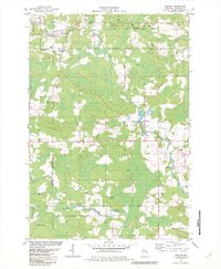
1982 Map of Bowler
USGS Topo · Published 1982About this map
The North Branch Embarrass River and its numerous tributaries, including Pony Creek and Hennig Creek, define the water-rich landscape of Shawano County in the early 1980s. The village of Bowler serves as a northern anchor, positioned near the Stockbridge-Munsee Indian Reservation Boundary and the line of the Chicago and North Western railroad. Further south, the rural character is evident in the small settlements of Tilleda and Leopolis, where local life centered around community landmarks like Trinko Park and Bethany Ch. The landscape is a network of family-named roads such as Aschenbrener Lane and Breitenfeldt Road, which connect scattered agricultural lands and several local Gravel Pits. This survey captures the region just as modern environmental infrastructure, like the Sewage Disposal Ponds, began to appear alongside traditional sites like Peace Cem.
Find a feature on this map
36 named features on this map. Tap any name to fly to it.
Don’t see what you’re looking for? This feature index may not catch every label — zoom into the map to look around manually.
Map Details
Editions of this 1982 Bowler Map
This is the sole edition of this map. No revisions or reprints were ever made.
Other maps of this area

1954 · Wittenberg
USGS Topo · 1:48,000

1954 · Gresham
USGS Topo · 1:48,000

1955 · Clintonville
USGS Topo · 1:48,000

1955 · Tigerton
USGS Topo · 1:48,000

1955 · Green Bay
USGS Topo · 1:250,000

1964 · Wittenberg
USGS Topo · 1:62,500

1964 · Gresham
USGS Topo · 1:62,500

1970 · Clintonville North
USGS Topo · 1:24,000
1970 · Marion
USGS Topo · 1:24,000
1970 · Tigerton
USGS Topo · 1:24,000