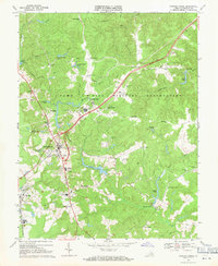
1969 Map of Bowling Green
USGS Topo · Published 1971About this map
Bowling Green serves as the focal point of this late 1960s study, situated just west of the expansive Camp A P Hill Military Reservation. The map captures a transitional period for this part of Caroline County, where the historic town center at Bowling Green and the nearby rail-oriented community of Milford are surrounded by family-named corners and rural settlements. A cluster of educational and social landmarks, including Caroline High School, Union High School, and several cemeteries like Green Lawn Cem and Evergreen Cem, highlight the area's established social fabric. The landscape is defined by the winding course of Maracossic Creek and Peumansend Creek, along with various agricultural ponds and the Richmond Fredericksburg and Potomac railroad line. The presence of numerous observation towers and military infrastructure within the reservation boundaries contrasts with the quiet crossroads of Honeysuckle Gate, Acors Corner, and Poorhouse Corner.
Find a feature on this map
58 named features on this map. Tap any name to fly to it.
Don’t see what you’re looking for? This feature index may not catch every label — zoom into the map to look around manually.
Map Details
Editions of this 1969 Bowling Green Map
4 editions found
Other maps of this area

1889 · Fredericksburg
USGS Topo · 1:125,000

1892 · Fredericksburg
USGS Topo · 1:125,000

1894 · Fredericksburg
USGS Topo · 1:125,000

1918 · Doswell
USGS Topo · 1:62,500

1918 · Aylett
USGS Topo · 1:62,500

1933 · Aylett
USGS Topo · 1:62,500

1942 · Bowling Green
USGS Topo · 1:31,680

1942 · Upper Zion
USGS Topo · 1:31,680

1942 · Woodford
USGS Topo · 1:31,680

1942 · Guinea
USGS Topo · 1:31,680