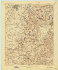
1923 Map of Bowling Green
USGS Topo · Published 1936About this map
Bowling Green serves as the focal point for this early 1920s survey of south-central Kentucky, where the Louisville and Nashville RR bisects the landscape near Memphis Junction. The intricate meandering of the Barren River and its major tributaries, including Drake Creek and Bays Fork, dictates the region's transport patterns, with numerous river crossings and landings visible before modern bridge infrastructure dominated. Local commerce and community life in this era were centered around small rural nodes such as Cassadays Store, Alvaton, and Allen Springs.
Find a feature on this map
74 named features on this map. Tap any name to fly to it.
Don’t see what you’re looking for? This feature index may not catch every label — zoom into the map to look around manually.
Map Details
Editions of this 1923 Bowling Green Map
4 editions found
Other maps of this area

1914 · Little Muddy
USGS Topo · 1:62,500

1921 · Bowling Green
USGS Topo · 1:62,500

1922 · Brownsville
USGS Topo · 1:62,500

1922 · Mammoth Cave
USGS Topo · 1:62,500

1923 · Bowling Green
USGS Topo · 1:62,500

1923 · Mammoth Cave
USGS Topo · 1:62,500

1923 · Brownsville
USGS Topo · 1:62,500

1926 · Scottsville
USGS Topo · 1:62,500

1928 · Adolphus
USGS Topo · 1:48,000

1931 · Lafayette
USGS Topo · 1:62,500