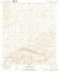
1957 Map of Box Canyon Ranch
USGS Topo · Published 1979About this map
Cass Ranch and the namesake Box Canyon Ranch anchor this landscape of the High Plains in Eddy County, as documented through planetable surveys in the late 1950s. The terrain is defined by a dense network of intermittent drainage channels, including the evocatively named Strychnine Draw, Cat Claw Draw, and the extensive North Prong Long Draw. These draws converge toward the dramatic relief of Box Canyon and Little Box Canyon in the southern portion of the quadrangle.
Find a feature on this map
18 named features on this map. Tap any name to fly to it.
Don’t see what you’re looking for? This feature index may not catch every label — zoom into the map to look around manually.
Map Details
Editions of this 1957 Box Canyon Ranch Map
2 editions found
Other maps of this area

1940 · Bandanna Point
USGS Topo · 1:62,500

1943 · Bandanna Point
USGS Topo · 1:62,500

1943 · Texas Hill
USGS Topo · 1:62,500

1945 · Texas Hill
USGS Topo · 1:62,500

1954 · Carlsbad
USGS Topo · 1:250,000

1956 · Parish Ranch
USGS Topo · 1:24,000

1956 · Antelope Sink
USGS Topo · 1:24,000

1957 · Foster Ranch
USGS Topo · 1:24,000

1957 · Box Canyon Ranch
USGS Topo · 1:24,000

1958 · Carlsbad
USGS Topo · 1:250,000