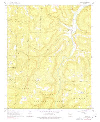
1968 Map of Boxley
USGS Topo · Published 1977About this map
Buffalo River headwaters and the deep valleys of the Ozark National Forest dominate this landscape during the late 1960s. The settlement at Boxley serves as a focal point along the river, where the Walnut Grove Ch and Walnut Grove Cem stand as markers of the local community. The terrain is defined by a dense network of hollows, including Harve Lewis Hollow and Cook Hollow, which drain from the high ridges of Boston Mountain and Reeves Mountain.
Find a feature on this map
47 named features on this map. Tap any name to fly to it.
Don’t see what you’re looking for? This feature index may not catch every label — zoom into the map to look around manually.
Map Details
Editions of this 1968 Boxley Map
3 editions found
Other maps of this area

1900 · Eureka Springs
USGS Topo · 1:125,000

1901 · Eureka Springs
USGS Topo · 1:125,000

1904 · Harrison
USGS Topo · 1:125,000

1905 · Harrison
USGS Topo · 1:125,000

1945 · Harrison
USGS Topo · 1:250,000

1949 · Harrison
USGS Topo · 1:250,000

1954 · Harrison
USGS Topo · 1:250,000

1956 · Russellville
USGS Topo · 1:250,000

1958 · Harrison
USGS Topo · 1:250,000

1964 · Russellville
USGS Topo · 1:250,000