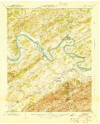
1940 Map of Boyds Creek
USGS Topo · Published 1940About this map
The French Broad River snakes through the heart of the Sevier and Knox county line, defining a landscape of deep meanders and alluvial islands. This 1940 survey documents a river-oriented society just before significant modern transitions, where river crossings like Huffaker Ferry and Johnson Ferry remained vital, even as the Brabson Ferry had already fallen out of use. The topography is anchored by the Bays Mountains and Smoky Mountain, with the John Sevier Monument standing near the banks of Boyds Creek. Small rural centers such as Seymour and Oak City are visible, supported by a dense network of local institutions including Harrison Chilhowee Academy and numerous community landmarks like Peters Mill and the Seven Islands Church. The map preserves the exact locations of many family-named cemeteries and rural schools, such as Trundle Cemetery and Highland View School, reflecting the ancestral footprint of the valley.
Find a feature on this map
84 named features on this map. Tap any name to fly to it.
Don’t see what you’re looking for? This feature index may not catch every label — zoom into the map to look around manually.
Map Details
Editions of this 1940 Boyds Creek Map
3 editions found
Other maps of this area

1886 · Knoxville
USGS Topo · 1:125,000

1892 · Knoxville
USGS Topo · 1:125,000

1894 · Knoxville
USGS Topo · 1:125,000

1895 · Knoxville
USGS Topo · 1:125,000

1897 · Maynardville
USGS Topo · 1:125,000

1900 · Maynardville
USGS Topo · 1:125,000

1901 · Knoxville
USGS Topo · 1:125,000

1935 · Mascot
USGS Topo · 1:24,000

1935 · Knoxville
USGS Topo · 1:48,000

1935 · Straw Plains
USGS Topo · 1:48,000