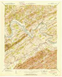
1940 Map of Boyds Creek
USGS Topo · Published 1952About this map
French Broad River winds through this landscape at the boundary of Knox and Sevier counties, carving distinctive features like Horseshoe Bend and Underwood Bend. The 1940 survey documents a transition in river transport, noting both the active Huffaker Ferry and the Brabson Ferry (Abandoned). Near the settlement of Boyds Creek, the John Sevier Monument stands as a landmark of regional history. The rural community is densely marked with small family cemeteries such as Pollard Cem and Trundle Cem, and numerous local schools including Knight Sch, Payne Sch, and the Harrison Chilhowee Academy near the southern map edge. To the south, the terrain rises into the Slate Knobs and Whittle Mountain, while Peters Mill on Boyds Creek reflects the local water-powered industry of the era.
Find a feature on this map
72 named features on this map. Tap any name to fly to it.
Don’t see what you’re looking for? This feature index may not catch every label — zoom into the map to look around manually.
Map Details
Editions of this 1940 Boyds Creek Map
3 editions found
Other maps of this area

1886 · Knoxville
USGS Topo · 1:125,000

1892 · Knoxville
USGS Topo · 1:125,000

1894 · Knoxville
USGS Topo · 1:125,000

1895 · Knoxville
USGS Topo · 1:125,000

1897 · Maynardville
USGS Topo · 1:125,000

1900 · Maynardville
USGS Topo · 1:125,000

1901 · Knoxville
USGS Topo · 1:125,000

1935 · Mascot
USGS Topo · 1:24,000

1935 · Knoxville
USGS Topo · 1:48,000

1935 · Straw Plains
USGS Topo · 1:48,000