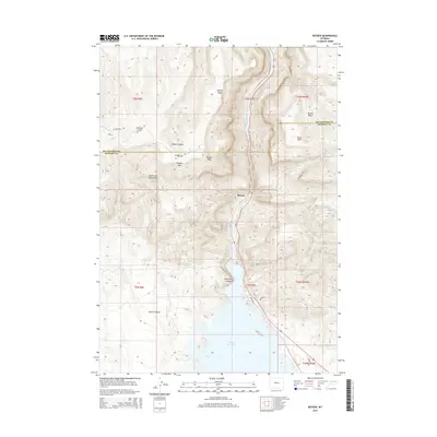
2015 Map of Boysen
USGS Topo · Published 2015About this map
The Wind River carves a dramatic path through the Wind River Canyon before entering the expanse of the Boysen Reservoir. This landscape is defined by the high elevations of the Owl Creek Mountains, where Boysen Peak and Stagner Mtn overlook the transition from narrow canyons to the broad reservoir waters. The small settlement of Boysen sits at this critical hydrological juncture, serving as a focal point near the northern end of the reservoir.
Find a feature on this map
28 named features on this map. Tap any name to fly to it.
Don’t see what you’re looking for? This feature index may not catch every label — zoom into the map to look around manually.
Map Details
Editions of this 2015 Boysen Map
This is the sole edition of this map. No revisions or reprints were ever made.
Other maps of this area

1950 · Bonneville SW
USGS Topo · 1:24,000

1951 · Mexican Pass SE
USGS Topo · 1:24,000

1951 · Boysen
USGS Topo · 1:24,000

1951 · Birdseye Pass
USGS Topo · 1:24,000

1951 · Morrison Canyon
USGS Topo · 1:24,000

1951 · Bonneville
USGS Topo · 1:24,000

1955 · Thermopolis
USGS Topo · 1:250,000
1957 · Bonneville
USGS Topo · 1:24,000

1958 · Thermopolis
USGS Topo · 1:250,000
1958 · Mexican Pass SE
USGS Topo · 1:24,000