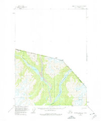
1955 Map of Bradfield canal B-3
USGS Topo · Published 1974About this map
The Tongass National Forest dominates this mid-century topographic study, capturing the wilderness interface where the Blue River and Unuk River carve through the borderlands between Alaska and British Columbia. This survey, based on 1948 aerial photography, provides a detailed look at the drainage patterns and glaciated terrain of the Coast Mountains before later environmental shifts. High peaks like Mt Stoeckl and Dickins Pk overlook a complex landscape of Crevasses and geothermal history indicated by the Lava Fork. The presence of Blue Lake and the steep walls of First Canyon illustrate the dramatic relief of this remote boundary region. Geologists and local historians can trace the intricate network of Trails and the natural boundary lines established between the Canada United States border and Albert Ridge.
Find a feature on this map
15 named features on this map. Tap any name to fly to it.
Don’t see what you’re looking for? This feature index may not catch every label — zoom into the map to look around manually.
Map Details
Editions of this 1955 Bradfield canal B-3 Map
3 editions found
Other maps of this area

1951 · Bradfield Canal
USGS Topo · 1:250,000

1954 · Bradfield Canal
USGS Topo · 1:250,000

1955 · Bradfield canal B-2
USGS Topo · 1:63,360

1955 · Bradfield canal B-3
USGS Topo · 1:63,360

1955 · Bradfield canal A-4
USGS Topo · 1:63,360

1955 · Bradfield canal A-2
USGS Topo · 1:63,360

1955 · Bradfield canal B-4
USGS Topo · 1:63,360

1955 · Bradfield canal A-3
USGS Topo · 1:63,360

1955 · Bradfield Canal
USGS Topo · 1:250,000
1973 · Bradfield Canal B-2
USGS Topo · 1:63,360