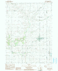
1983 Map of Bradford
USGS Topo · Published 1984About this map
The agricultural landscape of Stark County and neighboring Bureau County is defined by the intersection of major rail corridors and the winding course of the East Fork Spoon River. In the early 1980s, the village of Bradford served as a central hub, containing Hodges Park, an Apostolic Church, and a local High School. The map reveals a high density of rural burial grounds, including the Mt Pleasant Cemetery to the north and Champion Cemetery near the river, which serve as vital landmarks for family historians.
Find a feature on this map
36 named features on this map. Tap any name to fly to it.
Don’t see what you’re looking for? This feature index may not catch every label — zoom into the map to look around manually.
Map Details
Editions of this 1983 Bradford Map
2 editions found
Other maps of this area

1921 · Buda
USGS Topo · 1:62,500

1923 · Buda
USGS Topo · 1:62,500

1929 · Annawan
USGS Topo · 1:62,500

1932 · Annawan
USGS Topo · 1:62,500

1933 · Camp Grove
USGS Topo · 1:48,000

1944 · Kewanee
USGS Topo · 1:62,500

1945 · Bradford
USGS Topo · 1:62,500

1958 · Aurora
USGS Topo · 1:250,000

1961 · Aurora
USGS Topo · 1:250,000
1983 · Castleton
USGS Topo · 1:24,000