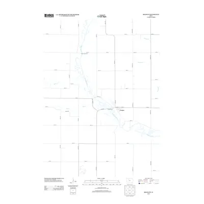
2013 Map of Bradgate
USGS Topo · Published 2013About this map
Bradgate sits along the northern banks of the Des Moines River, serving as a central point in this rural Humboldt County landscape during the early 21st century. The terrain is defined by its sophisticated drainage and water management systems, including the engineered Ditch Number 7 and several natural watercourses such as Bloody Run and Beaver Cr. This map documents a region where the natural meandering of the river meets a rigid, modern grid of agricultural roads, such as Pilot Creek Rd and Garfield Rd. Public recreation points like Hamms Bridge Access and Willows Access provide established entries to the river, indicating its continued importance for local leisure and transport even as the surrounding land is heavily utilized for farming. The presence of Pilot Cr and its associated road network further illustrates how local geography dictates the placement of secondary travel routes in this part of Iowa.
Find a feature on this map
43 named features on this map. Tap any name to fly to it.
Don’t see what you’re looking for? This feature index may not catch every label — zoom into the map to look around manually.
Map Details
Editions of this 2013 Bradgate Map
This is the sole edition of this map. No revisions or reprints were ever made.
Other maps of this area

1954 · Fort Dodge
USGS Topo · 1:250,000

1957 · Fort Dodge
USGS Topo · 1:250,000

1958 · Fort Dodge
USGS Topo · 1:250,000

1979 · Unique
USGS Topo · 1:24,000

1979 · Gilmore City
USGS Topo · 1:24,000

1979 · Palmer
USGS Topo · 1:24,000

1980 · Rolfe
USGS Topo · 1:24,000

1980 · Plover
USGS Topo · 1:24,000

1980 · West Bend
USGS Topo · 1:24,000
1980 · Bode
USGS Topo · 1:24,000