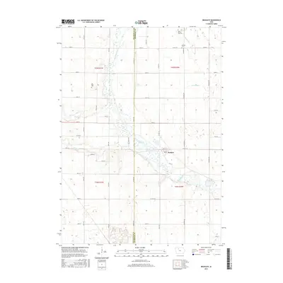
2015 Map of Bradgate
USGS Topo · Published 2015About this map
Bradgate serves as a central hub on this 2015 survey, situated near the winding course of the Des Moines River. This prairie landscape is intricately managed for agriculture, evidenced by an extensive network of drainage features like Ditch Number 7 and well-defined township roads such as Co Hwy C18. The map preserves valuable genealogical sites, including the Omer-Thorsen Farm Cem and McKnight Cem, which reflect the early family farmsteads of Humboldt and Pocahontas Counties. Of particular interest to local historians is the Old Rolfe Cem, marking the location of a predecessor settlement. Several small waterways, including Beaver Cr and Pilot Cr, feed into the river valley, while Bloody Run cuts through the northeast corner, illustrating the natural drainage patterns that define this rural Iowa landscape.
Find a feature on this map
50 named features on this map. Tap any name to fly to it.
Don’t see what you’re looking for? This feature index may not catch every label — zoom into the map to look around manually.
Map Details
Editions of this 2015 Bradgate Map
This is the sole edition of this map. No revisions or reprints were ever made.
Other maps of this area

1954 · Fort Dodge
USGS Topo · 1:250,000

1957 · Fort Dodge
USGS Topo · 1:250,000

1958 · Fort Dodge
USGS Topo · 1:250,000

1979 · Unique
USGS Topo · 1:24,000

1979 · Gilmore City
USGS Topo · 1:24,000

1979 · Palmer
USGS Topo · 1:24,000

1980 · Rolfe
USGS Topo · 1:24,000

1980 · Plover
USGS Topo · 1:24,000

1980 · West Bend
USGS Topo · 1:24,000
1980 · Bode
USGS Topo · 1:24,000