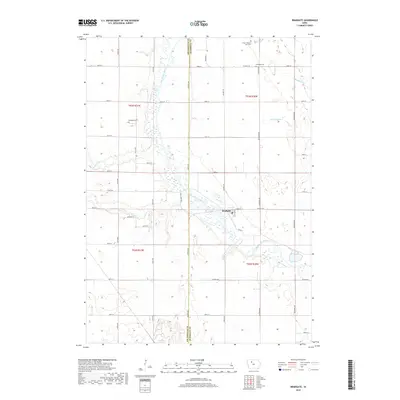
2018 Map of Bradgate
USGS Topo · Published 2018About this map
Bradgate stands at the heart of this landscape, positioned along a winding segment of the Des Moines River where the borders of Pocahontas and Humboldt counties meet. The terrain is defined by its water management and agricultural heritage, featuring natural waterways like Beaver Creek and Pilot Creek alongside human-engineered features such as Ditch Number 7. This 2018 survey provides an essential reference for genealogists, as it documents several small, specialized burial sites that speak to the area's early settlement history.
Find a feature on this map
50 named features on this map. Tap any name to fly to it.
Don’t see what you’re looking for? This feature index may not catch every label — zoom into the map to look around manually.
Map Details
Editions of this 2018 Bradgate Map
This is the sole edition of this map. No revisions or reprints were ever made.
Other maps of this area

1954 · Fort Dodge
USGS Topo · 1:250,000

1957 · Fort Dodge
USGS Topo · 1:250,000

1958 · Fort Dodge
USGS Topo · 1:250,000

1979 · Unique
USGS Topo · 1:24,000

1979 · Gilmore City
USGS Topo · 1:24,000

1979 · Palmer
USGS Topo · 1:24,000

1980 · Rolfe
USGS Topo · 1:24,000

1980 · Plover
USGS Topo · 1:24,000

1980 · West Bend
USGS Topo · 1:24,000
1980 · Bode
USGS Topo · 1:24,000