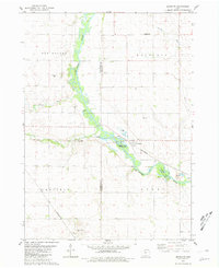
1980 Map of Bradgate
USGS Topo · Published 1981About this map
The Des Moines River winds through this central Iowa landscape, defining the transition between the townships of Wacousta, Avery, Garfield, and Des Moines. The village of Bradgate serves as a local hub, situated along the Chicago and North Western railroad line. This 1980 survey captures a rural economy where traditional agriculture intersects with riparian recreation at the Bradgate State Fishing Access and Pilot Creek County Park. Genealogists and local historians will find the locations of McKnight Cem and Old Rolfe Cem, alongside the small settlement of Jolliffe in the northern reaches. The terrain is further marked by significant watercourses including Beaver Creek, Pilot Creek, and the uniquely named Bloody Run, while various gravel pits and quarries highlight the local extraction industry during this era.
Find a feature on this map
23 named features on this map. Tap any name to fly to it.
Don’t see what you’re looking for? This feature index may not catch every label — zoom into the map to look around manually.
Map Details
Editions of this 1980 Bradgate Map
This is the sole edition of this map. No revisions or reprints were ever made.
Other maps of this area

1954 · Fort Dodge
USGS Topo · 1:250,000

1957 · Fort Dodge
USGS Topo · 1:250,000

1958 · Fort Dodge
USGS Topo · 1:250,000

1979 · Unique
USGS Topo · 1:24,000

1979 · Gilmore City
USGS Topo · 1:24,000

1979 · Palmer
USGS Topo · 1:24,000

1980 · Rolfe
USGS Topo · 1:24,000

1980 · Plover
USGS Topo · 1:24,000

1980 · West Bend
USGS Topo · 1:24,000
1980 · Bode
USGS Topo · 1:24,000