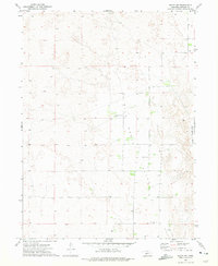
1972 Map of Brady NE
USGS Topo · Published 1975About this map
Wild Horse Valley dominates the topography of this section of Lincoln County, where the landscape is defined by the undulating patterns of the Nebraska sandhills. During the early 1970s, this area remained largely open rangeland, marked by the presence of the Wild Horse Valley Ranch and scattered water sources labeled simply as Well. The social fabric of this rural community is anchored by the Spannuth Sch and the Svea-Dal Cem, features that provide critical touchpoints for genealogists and local historians tracing the settlement of the Platte River valley hinterlands. The map's detailed survey of fence and field lines illustrates the organized partition of the valley, reflecting the enduring cattle ranching and agricultural traditions that have shaped the region's development far from major urban centers.
Find a feature on this map
8 named features on this map. Tap any name to fly to it.
Don’t see what you’re looking for? This feature index may not catch every label — zoom into the map to look around manually.
Map Details
Editions of this 1972 Brady NE Map
This is the sole edition of this map. No revisions or reprints were ever made.
Other maps of this area

1954 · North Platte
USGS Topo · 1:250,000

1956 · North Platte
USGS Topo · 1:250,000

1957 · North Platte
USGS Topo · 1:250,000

1967 · North Platte
USGS Topo · 1:250,000
1970 · Brady SW
USGS Topo · 1:24,000
1970 · Brady
USGS Topo · 1:24,000
1972 · Odencranze Table South
USGS Topo · 1:24,000
1972 · Odencranze Table North
USGS Topo · 1:24,000
1972 · Brady NW
USGS Topo · 1:24,000
1972 · Gandy SW
USGS Topo · 1:24,000