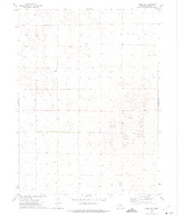
1972 Map of Gandy SW
USGS Topo · Published 1975About this map
Brosius Ranch and Bailey Ranch stand as primary landmarks in this high plains landscape of Lincoln County, Nebraska. Mapped in the early 1970s, the terrain is defined by a sparse distribution of agricultural infrastructure, characterized by isolated cattle ranches and scattered wells that support livestock in an arid environment. The map provides a look at the rural land management of the era, with fine red dashed lines indicating fence and field boundaries that delineate the vast grazing lands of the Sandhills region. This specific quadrangle captures the essential isolation of ranching life, where large tracts of land are organized by the township and range system, specifically marking the transition between T. 16 N. and T. 15 N. in a territory where water sources are the most critical topographic features.
Find a feature on this map
4 named features on this map. Tap any name to fly to it.
Don’t see what you’re looking for? This feature index may not catch every label — zoom into the map to look around manually.
Map Details
Editions of this 1972 Gandy SW Map
This is the sole edition of this map. No revisions or reprints were ever made.
Other maps of this area

1899 · North Platte
USGS Topo · 1:125,000

1902 · North Platte
USGS Topo · 1:125,000

1954 · North Platte
USGS Topo · 1:250,000

1956 · North Platte
USGS Topo · 1:250,000

1957 · North Platte
USGS Topo · 1:250,000

1967 · North Platte
USGS Topo · 1:250,000
1970 · Maxwell NE
USGS Topo · 1:24,000
1972 · Stapleton
USGS Topo · 1:24,000

1972 · Logan
USGS Topo · 1:24,000
1972 · Stapleton SE
USGS Topo · 1:24,000