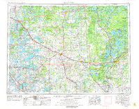
1953 Map of Brainerd
USGS Topo · Published 1977About this map
The Mississippi River and Crow Wing River converge at the heart of this central Minnesota landscape, where the growing city of Brainerd stands as a rail and commerce hub. By the mid-1950s, the region was defined by a dense network of timberlands and protected spaces, including the Chippewa National Forest, Smoky Hills State Forest, and the sprawling Camp Ripley Military Reservation. This map captures the intricate water system of the lakes district, showing the Otter Tail River winding toward Otter Tail Lake and the significant shoreline of Gull Lake. The transportation infrastructure is anchored by the Northern Pacific Railway and Burlington Northern Railroad, which connect industrial points like Staples and Wadena to the recreational corridors around Detroit Lakes. Large portions of tribal lands, specifically the White Earth Indian Reservation and Leech Lake Indian Reservation, reflect the complex jurisdictional history of the northern woods.
Find a feature on this map
237 named features on this map. Tap any name to fly to it.
Don’t see what you’re looking for? This feature index may not catch every label — zoom into the map to look around manually.
Map Details
Editions of this 1953 Brainerd Map
3 editions found

Other maps of this area

1910 · Wendell
USGS Topo · 1:62,500

1911 · Barrett
USGS Topo · 1:62,500

1911 · Herman
USGS Topo · 1:62,500

1912 · Deerwood
USGS Topo · 1:62,500

1912 · Vergas
USGS Topo · 1:62,500

1912 · Battle Lake
USGS Topo · 1:62,500

1913 · Ashby
USGS Topo · 1:62,500

1913 · Fergus Falls
USGS Topo · 1:62,500

1913 · Wendell
USGS Topo · 1:62,500

1913 · Cuyuna
USGS Topo · 1:62,500