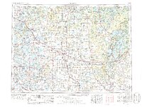
1953 Map of Brainerd
USGS Topo · Published 1977About this map
Brainerd serves as the eastern hub of this mid-century landscape, situated along the Crow Wing River as it passes through a region of dense forests and thousands of small lakes. The transportation network is dominated by the Northern Pacific RR and the Great Northern RR, which intersect at critical junctions like Wadena and Detroit Lakes. These rail lines facilitated the movement of timber and agricultural products across Central Minnesota, connecting remote outposts such as Wolf Lake and Nimrod to regional markets.
Find a feature on this map
167 named features on this map. Tap any name to fly to it.
Don’t see what you’re looking for? This feature index may not catch every label — zoom into the map to look around manually.
Map Details
Editions of this 1953 Brainerd Map
3 editions found

Other maps of this area

1910 · Wendell
USGS Topo · 1:62,500

1911 · Barrett
USGS Topo · 1:62,500

1911 · Herman
USGS Topo · 1:62,500

1912 · Deerwood
USGS Topo · 1:62,500

1912 · Vergas
USGS Topo · 1:62,500

1912 · Battle Lake
USGS Topo · 1:62,500

1913 · Ashby
USGS Topo · 1:62,500

1913 · Fergus Falls
USGS Topo · 1:62,500

1913 · Wendell
USGS Topo · 1:62,500

1913 · Cuyuna
USGS Topo · 1:62,500