
1947 Map of Branch
USGS Topo · Published 1947About this map
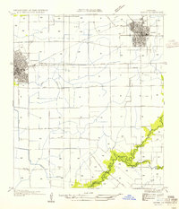
Branch sits at the northeastern corner of this 1947 landscape, where the Texas and Pacific Railway runs parallel to State Highway No 40. The area is defined by its intricate drainage network, featuring the winding courses of Bayou Plaquemine and Brule Bayou Plaquemine alongside smaller waterways like Coles Gully and Bidemian Gully.
Find a feature on this map
23 named features on this map. Tap any name to fly to it.
Don’t see what you’re looking for? This feature index may not catch every label — zoom into the map to look around manually.
Map Details
Editions of this 1947 Branch Map
This is the sole edition of this map. No revisions or reprints were ever made.
Other maps of this area

1934 · Duson
USGS Topo · 1:31,680

1935 · Branch
USGS Topo · 1:31,680

1946 · Rayne
USGS Topo · 1:31,680

1947 · Eunice
USGS Topo · 1:31,680

1947 · Iota
USGS Topo · 1:31,680

1947 · Pitreville
USGS Topo · 1:31,680

1949 · Estherwood
USGS Topo · 1:31,680

1952 · Lake Charles
USGS Topo · 1:250,000

1954 · Duson
USGS Topo · 1:31,680
1954 · Rayne
USGS Topo · 1:31,680