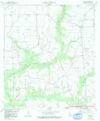
1983 Map of Branch
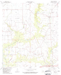
USGS Topo · Published 1991About this map
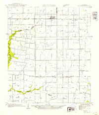
Bayou Plaquemine Brule and its complex network of drainage channels, including Hazelwood Gully and Biedeman Gully, dominate this landscape in Acadia Parish. The terrain is marked by the industrial footprint of the North Crowley Oil and Gas Field, where numerous wells and an extensive pipeline network crisscross the rural acreage. This 1980s survey illustrates a specialized aviation and agricultural economy, noted by several private airfields such as the Hensgens Landing Strip and Habetz Landing Strip.
Find a feature on this map
33 named features on this map. Tap any name to fly to it.
Don’t see what you’re looking for? This feature index may not catch every label — zoom into the map to look around manually.
Map Details
Editions of this 1983 Branch Map
2 editions found
Other maps of this area

1934 · Duson
USGS Topo · 1:31,680

1935 · Branch
USGS Topo · 1:31,680

1946 · Rayne
USGS Topo · 1:31,680

1947 · Branch
USGS Topo · 1:31,680

1947 · Eunice
USGS Topo · 1:31,680
1947 · Iota
USGS Topo · 1:31,680

1947 · Pitreville
USGS Topo · 1:31,680
1949 · Estherwood
USGS Topo · 1:31,680

1952 · Lake Charles
USGS Topo · 1:250,000
1954 · Duson
USGS Topo · 1:31,680