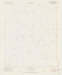
1967 Map of Branch Mtn
USGS Topo · Published 1968About this map
The La Panza Range defines this high-elevation landscape within the Los Padres National Forest, where 1960s ranching operations and water management systems adapted to the arid California terrain. Water security is central to the map's layout, evidenced by the concentration of developed water sources like the Taylor Well, Water Tank, and numerous named springs such as Grizzly Spring and Dutchman Spring. These sites supported isolated holdings like the Carrisa Ranch, Buckhorn Ranch, and Yeary Ranch. Higher elevations are marked by the Branch Mtn summit, which served as a critical communications hub featuring a Lookout Tower and Radio Facility. The drainage network, including San Juan Creek and the Gypsum Canyon Fork, underscores the topographic isolation of these mountains before modernized road access altered the character of the southern San Luis Obispo back country.
Find a feature on this map
50 named features on this map. Tap any name to fly to it.
Don’t see what you’re looking for? This feature index may not catch every label — zoom into the map to look around manually.
Map Details
Editions of this 1967 Branch Mtn Map
2 editions found
Other maps of this area

1912 · McKittrick
USGS Topo · 1:125,000

1932 · La Panza
USGS Topo · 1:48,000

1935 · La Panza
USGS Topo · 1:62,500

1936 · La Panza
USGS Topo · 1:62,500

1937 · Branch Mtn
USGS Topo · 1:48,000

1941 · Caliente Mountain
USGS Topo · 1:62,500

1942 · Branch Mountain
USGS Topo · 1:62,500

1942 · Caliente Mtn
USGS Topo · 1:62,500

1943 · Simmler
USGS Topo · 1:62,500

1943 · Caliente Mtn.
USGS Topo · 1:62,500