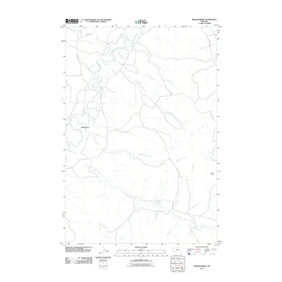
2011 Map of Brandenberg
USGS Topo · Published 2011About this map
Brandenberg sits at a geographic pivot point in Rosebud County, where the meandering Tongue River receives the waters of Straight Creek and Diamond Creek. This 2011 survey illustrates a landscape defined by its riparian corridors and high prairie relief, anchored by the landmark of Red Butte. The settlement pattern follows the natural hydrology, with ranch roads like Beaver Creek Rd and Liscom Creek Rd tracing the drainage basins of Beaver Creek and Liscom Creek. The map details a network of smaller intermittent streams, including Goodale Creek, Big John Creek, and Freda Creek, which carve into the terrain east of the river valley. For the researcher, the map reveals the complex hydrography of the region, from the primary river channel to the small draws like Dugout Creek and Riddle Creek that shape this portion of the Montana range.
Find a feature on this map
24 named features on this map. Tap any name to fly to it.
Don’t see what you’re looking for? This feature index may not catch every label — zoom into the map to look around manually.
Map Details
Editions of this 2011 Brandenberg Map
This is the sole edition of this map. No revisions or reprints were ever made.
Other maps of this area

1954 · Hardin
USGS Topo · 1:250,000

1957 · Hardin
USGS Topo · 1:250,000

1958 · Hardin
USGS Topo · 1:250,000

1966 · Beaver Creek School
USGS Topo · 1:24,000

1966 · Cook Creek Reservoir
USGS Topo · 1:24,000

1966 · Ashland NE
USGS Topo · 1:24,000
1971 · Brandenberg NW
USGS Topo · 1:24,000

1971 · Hammond Draw
USGS Topo · 1:24,000
1971 · Hayes Point
USGS Topo · 1:24,000
1971 · HS School
USGS Topo · 1:24,000