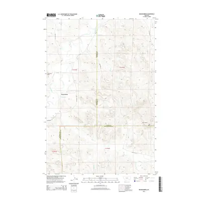
2014 Map of Brandenberg
USGS Topo · Published 2014About this map
The Tongue River meanders through this landscape, defining the topography of eastern Montana at the junction of Rosebud, Custer, and Powder River counties. The small settlement of Brandenberg serves as a focal point along MT-332, situated near the confluence of several vital watercourses including Diamond Cr and Straight Cr. This area is characterized by its complex network of seasonal creeks and drainage coulees that feed into the river valley, illustrating the hydrological patterns essential to ranching and local land use in the region.
Find a feature on this map
34 named features on this map. Tap any name to fly to it.
Don’t see what you’re looking for? This feature index may not catch every label — zoom into the map to look around manually.
Map Details
Editions of this 2014 Brandenberg Map
This is the sole edition of this map. No revisions or reprints were ever made.
Other maps of this area

1954 · Hardin
USGS Topo · 1:250,000

1957 · Hardin
USGS Topo · 1:250,000

1958 · Hardin
USGS Topo · 1:250,000

1966 · Beaver Creek School
USGS Topo · 1:24,000

1966 · Cook Creek Reservoir
USGS Topo · 1:24,000

1966 · Ashland NE
USGS Topo · 1:24,000
1971 · Brandenberg NW
USGS Topo · 1:24,000

1971 · Hammond Draw
USGS Topo · 1:24,000
1971 · Hayes Point
USGS Topo · 1:24,000
1971 · HS School
USGS Topo · 1:24,000