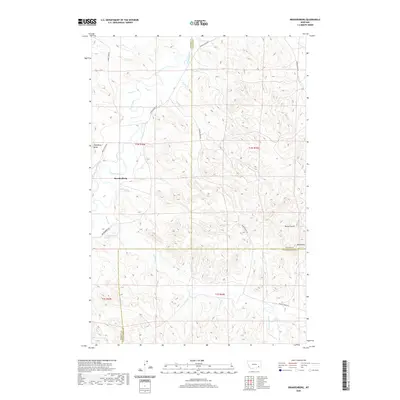
2020 Map of Brandenberg
USGS Topo · Published 2020About this map
The Tongue River defines the western landscape of this region in Rosebud County, where the small settlement of Brandenberg sits near the river's winding course. This modern survey illustrates a landscape of complex drainage patterns, with numerous tributaries such as Big John Cr, Goodale Cr, and Diamond Cr carving through the terrain. The map's detail extends to geological landmarks like Trembling Butte and Red Butte, which serve as prominent navigational points in a topography otherwise dominated by coulees and creek beds.
Find a feature on this map
31 named features on this map. Tap any name to fly to it.
Don’t see what you’re looking for? This feature index may not catch every label — zoom into the map to look around manually.
Map Details
Editions of this 2020 Brandenberg Map
This is the sole edition of this map. No revisions or reprints were ever made.
Other maps of this area

1954 · Hardin
USGS Topo · 1:250,000

1957 · Hardin
USGS Topo · 1:250,000

1958 · Hardin
USGS Topo · 1:250,000

1966 · Beaver Creek School
USGS Topo · 1:24,000

1966 · Cook Creek Reservoir
USGS Topo · 1:24,000

1966 · Ashland NE
USGS Topo · 1:24,000
1971 · Brandenberg NW
USGS Topo · 1:24,000

1971 · Hammond Draw
USGS Topo · 1:24,000
1971 · Hayes Point
USGS Topo · 1:24,000
1971 · HS School
USGS Topo · 1:24,000