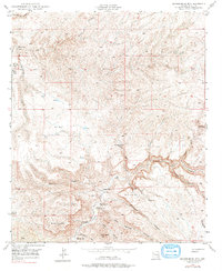
1949 Map of Brandenburg Mtn
USGS Topo · Published 1979About this map
Aravaipa Creek carves a deep path through this Pinal County landscape, serving as the primary corridor for human activity and ranching in the late 1940s. The settlement pattern is defined by family-named holdings and seasonal outposts, including Wagner Ranch, Woods Ranch, and Lewis Ranch, which clustered near water sources in an otherwise arid environment. This 1947–1949 survey documents a transition between high peaks like Brandenburg Mtn and the canyon floors where early habitation took root.
Find a feature on this map
39 named features on this map. Tap any name to fly to it.
Don’t see what you’re looking for? This feature index may not catch every label — zoom into the map to look around manually.
Map Details
Editions of this 1949 Brandenburg Mtn Map
4 editions found
Other maps of this area

1911 · Winkelman
USGS Topo · 1:125,000

1913 · Winkelman
USGS Topo · 1:125,000

1915 · Christmas
USGS Topo · 1:62,500

1917 · Christmas
USGS Topo · 1:62,500

1938 · Klondyke
USGS Topo · 1:48,000

1943 · Klondyke
USGS Topo · 1:62,500

1949 · Holy Joe Peak
USGS Topo · 1:62,500

1949 · Saddle Mtn.
USGS Topo · 1:24,000

1949 · Brandenburg Mtn
USGS Topo · 1:24,000
1949 · Holy Joe Peak
USGS Topo · 1:24,000