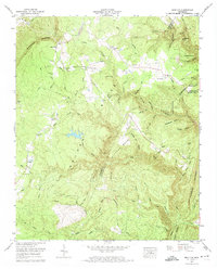
1972 Map of Brayton
USGS Topo · Published 1974About this map
Walden Ridge dominates this 1972 survey, where the Cumberland Escarpment drops away into the complex drainages of Bledsoe, Rhea, and Hamilton counties. The landscape is defined by its industrial history and scattered mountain settlements, notably Brayton, Smithtown, and Hickory Grove. Numerous strip mines and a quarry are visible across the high ground, particularly near The Backbone and Pitts Gap. This era reveals a community closely tied to its geography, with local life centered around the Brayton-Hendon Community Center and Brayton Ch. For genealogists, the map preserves the locations of family burial grounds like Metz Cem, Hendon Cem, and Standifer Cem. The topography is particularly intricate through McGill Gulf and along the winding course of Rock Creek, which carves through the sandstone before reaching Clifton Bend.
Find a feature on this map
89 named features on this map. Tap any name to fly to it.
Don’t see what you’re looking for? This feature index may not catch every label — zoom into the map to look around manually.
Map Details
Editions of this 1972 Brayton Map
2 editions found
Other maps of this area

1888 · Chattanooga
USGS Topo · 1:125,000

1892 · Pikeville
USGS Topo · 1:125,000

1893 · Chattanooga
USGS Topo · 1:125,000

1895 · Pikeville
USGS Topo · 1:125,000

1909 · Sequatchie Valley
USGS Topo · 1:62,500

1910 · Pikeville
USGS Topo · 1:62,500

1935 · Morgan Springs
USGS Topo · 1:24,000

1935 · Soddy
USGS Topo · 1:24,000

1935 · Brockdell
USGS Topo · 1:24,000

1935 · Brayton
USGS Topo · 1:24,000