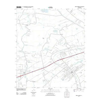
2012 Map of Breaux Bridge
USGS Topo · Published 2012About this map
The winding course of Bayou Teche defines this landscape, where the traditional Acadiana settlement patterns of the early twenty-first century meet the heavy footprint of the energy industry. Breaux Bridge serves as the primary hub, with local geography further marked by smaller communities like Gecko and Bushville. The southern portion of the map is dominated by extensive petroleum infrastructure, specifically the Anse La Butte Oil and Gas Field and the East Anse La Butte Oil Field, illustrating the economic drivers of the region. Drainage and navigation are central to the terrain, evidenced by the Magenta Canal and numerous coulees such as Coulee Crocodrie. Cultural landmarks, including the Saint Bernard Cem and the Optimist Boys Camp, provide specific points of interest for genealogists and local historians tracing the development of Lafayette Parish and the surrounding bayou country.
Find a feature on this map
176 named features on this map. Tap any name to fly to it.
Don’t see what you’re looking for? This feature index may not catch every label — zoom into the map to look around manually.
Map Details
Editions of this 2012 Breaux Bridge Map
This is the sole edition of this map. No revisions or reprints were ever made.
Other maps of this area

1939 · St. Martinsville
USGS Topo · 1:62,500

1940 · Arnaudville
USGS Topo · 1:62,500

1946 · Lafayette
USGS Topo · 1:31,680

1952 · Lake Charles
USGS Topo · 1:250,000

1954 · Lafayette
USGS Topo · 1:31,680

1954 · Lake Charles
USGS Topo · 1:250,000

1954 · Baton Rouge
USGS Topo · 1:250,000

1955 · Lafayette
USGS Topo · 1:24,000
1955 · Lafayette
USGS Topo · 1:62,500

1956 · Baton Rouge
USGS Topo · 1:250,000