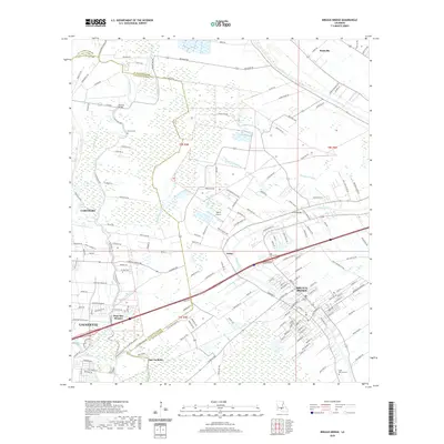
2020 Map of Breaux Bridge
USGS Topo · Published 2020About this map
The Bayou Teche snakes through the heart of the Acadiana landscape, anchoring the historic community of Breaux Bridge. This modern topographic survey illustrates the density of the region's unique hydraulic network, where natural features like Bayou Saint Clair and Bayou Pont Brule are integrated with man-made improvements such as the Magenta Canal. The map reveals the eastward expansion of Lafayette towards the St. Martin Parish line, connecting smaller settlements like Gecko and Pont Des Mouton.
Find a feature on this map
165 named features on this map. Tap any name to fly to it.
Don’t see what you’re looking for? This feature index may not catch every label — zoom into the map to look around manually.
Map Details
Editions of this 2020 Breaux Bridge Map
This is the sole edition of this map. No revisions or reprints were ever made.
Other maps of this area

1939 · St. Martinsville
USGS Topo · 1:62,500

1940 · Arnaudville
USGS Topo · 1:62,500

1946 · Lafayette
USGS Topo · 1:31,680

1952 · Lake Charles
USGS Topo · 1:250,000

1954 · Lafayette
USGS Topo · 1:31,680

1954 · Lake Charles
USGS Topo · 1:250,000

1954 · Baton Rouge
USGS Topo · 1:250,000

1955 · Lafayette
USGS Topo · 1:24,000
1955 · Lafayette
USGS Topo · 1:62,500

1956 · Baton Rouge
USGS Topo · 1:250,000