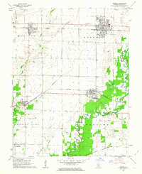
1962 Map of Breese
USGS Topo · Published 1963About this map
The Baltimore and Ohio and Southern railroads anchor the industrial and agricultural landscape of Clinton County in the early 1960s. These rail corridors connect the established towns of Breese, Aviston, and Germantown, which serve as local hubs for grain and commerce. The map reveals a community deeply rooted in its local institutions, evidenced by parochial landmarks like Mater Dei High Sch, St Johns Cem, and St Bernards Cem.
Find a feature on this map
34 named features on this map. Tap any name to fly to it.
Don’t see what you’re looking for? This feature index may not catch every label — zoom into the map to look around manually.
Map Details
Editions of this 1962 Breese Map
2 editions found
Other maps of this area

1906 · Breese
USGS Topo · 1:62,500

1907 · Breese
USGS Topo · 1:62,500

1910 · Carlyle
USGS Topo · 1:62,500

1910 · Okawville
USGS Topo · 1:62,500

1931 · Hoyleton
USGS Topo · 1:48,000

1932 · Nashville
USGS Topo · 1:62,500

1936 · Nashville
USGS Topo · 1:62,500

1940 · Okawville
USGS Topo · 1:62,500

1948 · Carlyle
USGS Topo · 1:62,500
1957 · Highland
USGS Topo · 1:24,000