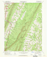
1967 Map of Breezewood
USGS Topo · Published 1970About this map
Breezewood serves as a pivotal junction in the late 1960s, where the Pennsylvania Toll Road meets the regional highway network amidst the deep ridges of the Bedford and Fulton county line. The landscape is defined by its topographic extremes, transitioning from the developed corridors around the toll road to the dense woodlands of Buchanan State Forest and State Game Lands No 65. Small, established communities like Akersville and Emmaville are tucked into the valleys of Roaring Run and Tonoloway Creek, reflecting an older, more isolated mountain economy that persists alongside modern transit. Local landmarks such as McKendree Ch and Ebenezer Ch provide essential points of reference for genealogists tracking family roots in these rural hollows. The presence of Sipes Mill and various mines indicates a history of local industry built around the area's natural resources.
Find a feature on this map
51 named features on this map. Tap any name to fly to it.
Don’t see what you’re looking for? This feature index may not catch every label — zoom into the map to look around manually.
Map Details
Editions of this 1967 Breezewood Map
3 editions found
Other maps of this area

1900 · Everett
USGS Topo · 1:62,500

1902 · Everett
USGS Topo · 1:62,500

1925 · Needmore
USGS Topo · 1:48,000

1927 · Clearville
USGS Topo · 1:48,000

1930 · Broad Top
USGS Topo · 1:62,500

1931 · Clearville
USGS Topo · 1:62,500

1933 · Broad Top
USGS Topo · 1:62,500

1935 · Needmore
USGS Topo · 1:62,500

1939 · Needmore
USGS Topo · 1:62,500

1944 · Clearville
USGS Topo · 1:62,500
Featured Places
- Gapsville, East Providence Township
- East Providence Township, PA
- Licking Creek Township, PA
- Akersville, Brush Creek Township
- Sipes Mill, Belfast Township