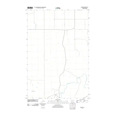
2011 Map of Breien
USGS Topo · Published 2011About this map
Breien sits at the southern edge of this prairie landscape, where Dogtooth Creek joins the winding Cannonball River. This region of Sioux County is defined by its wide drainage basins and significant landforms such as War Dance Hill, which rises above the western plains. The map illustrates a strictly organized rural grid of section lines and gravel routes, including 25th Ave and 71st ST, which facilitate movement between isolated homesteads and the river valley. In the northern reaches, the headwaters of the East Fork Chanta Peta Creek carve subtle coulees through the terrain. The presence of County Rd 134 connecting to the settlement at Breien underscores the enduring reliance on these traditional transport corridors in the North Dakota backcountry.
Find a feature on this map
13 named features on this map. Tap any name to fly to it.
Don’t see what you’re looking for? This feature index may not catch every label — zoom into the map to look around manually.
Map Details
Editions of this 2011 Breien Map
This is the sole edition of this map. No revisions or reprints were ever made.
Other maps of this area

1907 · Bismarck
USGS Topo · 1:125,000

1954 · Bismarck
USGS Topo · 1:250,000

1958 · Bismarck
USGS Topo · 1:250,000

1971 · Half Timber Butte
USGS Topo · 1:24,000

1971 · Solen SW
USGS Topo · 1:24,000

1971 · Timmer
USGS Topo · 1:24,000

1979 · Bismarck
USGS Topo · 1:100,000

1980 · Solen
USGS Topo · 1:24,000
1980 · The Hogback
USGS Topo · 1:24,000

1980 · Breien
USGS Topo · 1:24,000