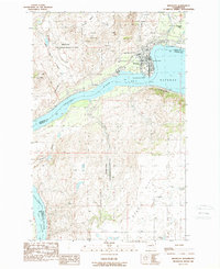
1989 Map of Brewster
USGS Topo · Published 1989About this map
Brewster sits at the confluence of the Okanogan and Columbia rivers, serving as the primary hub in this late-1980s landscape dominated by the expansive Columbia River Lake Pateros. The town's infrastructure is clearly visible, from the Sewage Disposal Pond and Pumping Station along the shoreline to the municipal Pool and various residential blocks. To the north and west, the terrain rises sharply into Harmony Heights and Tenas Mtn, where numerous stock tanks and corrals indicate a ranching economy bordering the Indian Dan State Wildlife Recreation Area. South of the river, Dyer Hill and Central Ferry Canyon define the Douglas County side, featuring a isolated Cem and Alexander Lake. This survey captures the region's character as a mix of river-bound utility and upland wildlife management within the Central Ferry State Wildlife Recreation Area.
Find a feature on this map
26 named features on this map. Tap any name to fly to it.
Don’t see what you’re looking for? This feature index may not catch every label — zoom into the map to look around manually.
Map Details
Editions of this 1989 Brewster Map
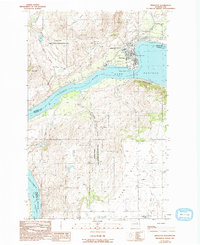
2 editions found
Other maps of this area

1905 · Okanogan
USGS Topo · 1:125,000

1953 · Ritzville
USGS Topo · 1:250,000

1954 · Okanogan
USGS Topo · 1:250,000

1957 · Bridgeport
USGS Topo · 1:62,500

1957 · Brewster
USGS Topo · 1:62,500

1958 · Okanogan
USGS Topo · 1:250,000

1959 · Ritzville
USGS Topo · 1:250,000

1965 · Ritzville
USGS Topo · 1:250,000

1968 · Chief Joseph Dam
USGS Topo · 1:24,000

1968 · Wells Dam
USGS Topo · 1:24,000