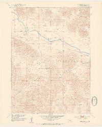
1952 Map of Brewster NW
USGS Topo · Published 1954About this map
North Loup River winds through the central portion of this 1952 topographic study, defining the low-lying valley between the sandy hills of Dunning and Brewster. The landscape is dominated by the broad expanse of Hawley Flats, a relatively level stretch where local ranching and agricultural activity centered during the mid-century. This map captures the remote rural infrastructure of Blaine County just after the war, evidenced by the presence of School No 3 and isolated windmills dotting the hillsides for water management. Transportation across the river was facilitated by localized crossings like the Pitt Bridge and BR 2504, which provided essential links between the partitioned townships. The survey illustrates a terrain primarily defined by its natural hydrology, with several springs feeding into the river system, supporting the sparse but established settlement patterns of the Nebraska Sandhills.
Find a feature on this map
12 named features on this map. Tap any name to fly to it.
Don’t see what you’re looking for? This feature index may not catch every label — zoom into the map to look around manually.
Map Details
Editions of this 1952 Brewster NW Map
3 editions found
Other maps of this area

1949 · Koshopah
USGS Topo · 1:62,500

1951 · Dunning
USGS Topo · 1:62,500

1951 · Koshopah
USGS Topo · 1:62,500

1952 · Brewster
USGS Topo · 1:24,000

1952 · Brewster SE
USGS Topo · 1:24,000

1952 · Brewster SW
USGS Topo · 1:24,000

1952 · Brewster NW
USGS Topo · 1:24,000

1954 · North Platte
USGS Topo · 1:250,000

1955 · Broken Bow
USGS Topo · 1:250,000

1955 · O'Neill
USGS Topo · 1:250,000