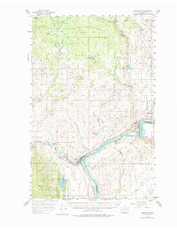
1957 Map of Brewster
USGS Topo · Published 1974About this map
The Columbia River and Methow River meet at the town of Pateros, anchoring a landscape defined by sharp elevation changes and riverside development. Further up the Columbia, the town of Brewster sits across the water from Douglas County, supported by the Great Northern railroad line that follows the northern riverbank. The survey captures the transition from irrigated valley floors like Brewster Flat to the higher elevations of the Okanogan National Forest.
Find a feature on this map
39 named features on this map. Tap any name to fly to it.
Don’t see what you’re looking for? This feature index may not catch every label — zoom into the map to look around manually.
Map Details
Editions of this 1957 Brewster Map
2 editions found

Other maps of this area

1899 · Methow
USGS Topo · 1:125,000

1901 · Chelan
USGS Topo · 1:125,000

1901 · Methow
USGS Topo · 1:125,000

1905 · Okanogan
USGS Topo · 1:125,000

1953 · Ritzville
USGS Topo · 1:250,000

1954 · Okanogan
USGS Topo · 1:250,000

1955 · Concrete
USGS Topo · 1:250,000

1956 · Loup Loup
USGS Topo · 1:62,500

1957 · Okanogan
USGS Topo · 1:62,500

1957 · Bridgeport
USGS Topo · 1:62,500