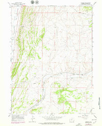
1965 Map of Bridger
USGS Topo · Published 1979About this map
Bridger and Antelope serve as the primary focal points of this high-altitude Wyoming landscape, situated along the vital east-west corridor of the Union Pacific railroad. The topography is defined by the striking north-south orientation of The Hogsback, which separates the wide Cumberland Flats to the west from the complex drainage systems of Muddy Creek and its various tributaries to the east. Several geological and industrial markers dot the area, including Gravel Pits near Clear Creek and a recorded Drill Hole in the northern interior. The local road network, including the Carter Cutoff Road and Highway 189, reflects a history of transit through the high desert, while landmarks like Scullys Gap and the family-named Albert provide essential orientation in this terrain of draws and springs.
Find a feature on this map
27 named features on this map. Tap any name to fly to it.
Don’t see what you’re looking for? This feature index may not catch every label — zoom into the map to look around manually.
Map Details
Editions of this 1965 Bridger Map
2 editions found
Other maps of this area

1954 · Ogden
USGS Topo · 1:250,000

1958 · Ogden
USGS Topo · 1:250,000

1960 · Ogden
USGS Topo · 1:250,000

1962 · Cumberland Gap
USGS Topo · 1:24,000

1962 · Elkol SW
USGS Topo · 1:24,000

1964 · Fort Bridger
USGS Topo · 1:24,000

1964 · Carter
USGS Topo · 1:24,000

1965 · Bridger
USGS Topo · 1:24,000

1965 · Ragan
USGS Topo · 1:24,000

1965 · Leroy
USGS Topo · 1:24,000