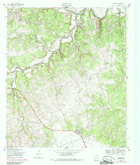
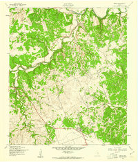
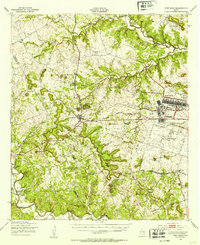
1958 Map of Briggs
USGS Topo · Published 1985About this map
Briggs and Oakalla anchor this detailed 1950s terrain study of northeastern Burnet Co, where the landscape is defined by the winding course of the Lampasas River and its numerous feeding drainages. The map reveals a rural economy centered on the highway corridor of 183, with small clusters of development and burial grounds such as Gillum Cem tucked into the rolling hills. The topography is marked by a series of named hollows, including Toby Hollow, Williams Hollow, and Tom Adams Hollow, which carve into the limestone uplands typical of the Texas Hill Country fringe.
Find a feature on this map
15 named features on this map. Tap any name to fly to it.
Don’t see what you’re looking for? This feature index may not catch every label — zoom into the map to look around manually.
Map Details
Editions of this 1958 Briggs Map
2 editions found
Other maps of this area

1887 · Lampasas
USGS Topo · 1:125,000

1887 · Burnet
USGS Topo · 1:125,000

1893 · Georgetown
USGS Topo · 1:125,000

1893 · Burnet
USGS Topo · 1:125,000

1894 · Lampasas
USGS Topo · 1:125,000

1894 · Gatesville
USGS Topo · 1:125,000

1903 · Burnet
USGS Topo · 1:125,000

1909 · Burnet
USGS Topo · 1:125,000
1947 · Fort Hood
USGS Topo · 1:62,500

1947 · McMillan Mountains
USGS Topo · 1:24,000