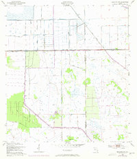
1953 Map of Brighton NW
USGS Topo · Published 1973About this map
Water management systems define this South Florida landscape along the border of Highlands Co and Glades Co. During the early 1950s, the U.S. Corps of Engineers documented a sophisticated network of drainage and flood control infrastructure, characterized by prominent features like Harney Pond Canal and Prairie Canal. The map illustrates the transformation of the region's hydrology through an extensive system of a Spoil Bank and Levee structures designed to reclaim land from the natural wetlands.
Find a feature on this map
11 named features on this map. Tap any name to fly to it.
Don’t see what you’re looking for? This feature index may not catch every label — zoom into the map to look around manually.
Map Details
Editions of this 1953 Brighton NW Map
3 editions found
Other maps of this area

1952 · Lake Placid
USGS Topo · 1:24,000

1953 · Brighton NW
USGS Topo · 1:24,000

1953 · Brighton SW
USGS Topo · 1:24,000

1953 · Fort Basinger
USGS Topo · 1:24,000

1953 · Brighton
USGS Topo · 1:24,000

1953 · Brighton SE
USGS Topo · 1:24,000

1953 · Basinger SW
USGS Topo · 1:24,000

1953 · Childs
USGS Topo · 1:24,000

1956 · Fort Pierce
USGS Topo · 1:250,000

1957 · Venus
USGS Topo · 1:24,000