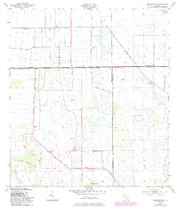
1953 Map of Brighton NW
USGS Topo · Published 1983About this map
The boundary between Highlands and Glades Counties cuts through a landscape defined by industrial water management and sprawling wetlands in the early 1950s. This drainage infrastructure is anchored by the Indian Prairie Canal and the Harney Pond Canal, which represent the massive mid-century efforts by the U.S. Army Corps of Engineers to control the Florida Everglades' watershed. These engineered waterways contrast sharply with the natural features they navigate, such as the expansive Bay Swamp and the isolated rise of Cabbage Island. The presence of numerous spoil banks and levees alongside Canal C-41 and Canal C-40 reveals the scale of earth-moving required to reclaim this marshland for agricultural or water-control purposes. This survey captures a specific phase of Florida's environmental transformation before later development further altered the region's hydrology.
Find a feature on this map
9 named features on this map. Tap any name to fly to it.
Don’t see what you’re looking for? This feature index may not catch every label — zoom into the map to look around manually.
Map Details
Editions of this 1953 Brighton NW Map
3 editions found
Other maps of this area

1952 · Lake Placid
USGS Topo · 1:24,000

1953 · Brighton NW
USGS Topo · 1:24,000

1953 · Brighton SW
USGS Topo · 1:24,000

1953 · Fort Basinger
USGS Topo · 1:24,000

1953 · Brighton
USGS Topo · 1:24,000

1953 · Brighton SE
USGS Topo · 1:24,000

1953 · Basinger SW
USGS Topo · 1:24,000

1953 · Childs
USGS Topo · 1:24,000

1956 · Fort Pierce
USGS Topo · 1:250,000

1957 · Venus
USGS Topo · 1:24,000