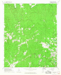
1967 Map of Brilliant
USGS Topo · Published 1968About this map
Brilliant stands as a primary hub of activity in this 1967 survey of Marion County, where the industrial presence of Strip Mine operations and the St Louis-San Francisco railroad line define the local economy. The landscape is carved by the Buttahatchee River and the winding Luxapallila Creek, with settlements like Pearces Mills and Yampertown connected by a network of unimproved roads and light-duty trails. Community life is anchored by numerous rural landmarks, from Mt Zion Ch to the High Sch in Brilliant.
Find a feature on this map
39 named features on this map. Tap any name to fly to it.
Don’t see what you’re looking for? This feature index may not catch every label — zoom into the map to look around manually.
Map Details
Editions of this 1967 Brilliant Map
3 editions found
Other maps of this area

1936 · South Of Hackleburg
USGS Topo · 1:24,000

1936 · Goddard
USGS Topo · 1:24,000

1953 · Birmingham
USGS Topo · 1:250,000

1956 · Birmingham
USGS Topo · 1:250,000

1956 · Gadsden
USGS Topo · 1:250,000

1957 · Birmingham
USGS Topo · 1:250,000

1958 · Gadsden
USGS Topo · 1:250,000
1958 · Haleyville West
USGS Topo · 1:24,000

1958 · Gold Mine
USGS Topo · 1:24,000

1960 · Gadsden
USGS Topo · 1:250,000