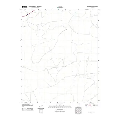
2010 Map of Briscoe Ranch
USGS Topo · Published 2010About this map
Briscoe Ranch serves as a primary landmark in this section of Quay County, illustrating the enduring cattle ranching heritage of eastern New Mexico. The landscape is defined by a dendritic network of seasonal waterways, including Bluewater Creek and Charco Creek, which cut through the high plains terrain. These drainages, alongside Blanca Creek and Garcia Creek, dictate the placement of local infrastructure and historic settlements. Small locales such as Kilgore and Jose appear alongside a sparse grid of rural roads like Quay Road 55 and Quay Road AT. This survey provides a clear view of the rural settlement patterns and water-dependent geography of the region at the beginning of the twenty-first century.
Find a feature on this map
12 named features on this map. Tap any name to fly to it.
Don’t see what you’re looking for? This feature index may not catch every label — zoom into the map to look around manually.
Map Details
Editions of this 2010 Briscoe Ranch Map
This is the sole edition of this map. No revisions or reprints were ever made.
Other maps of this area

1930 · Tucumcari
USGS Topo · 1:125,000

1954 · Tucumcari
USGS Topo · 1:250,000

1954 · Clovis
USGS Topo · 1:250,000

1958 · Clovis
USGS Topo · 1:250,000

1958 · Tucumcari
USGS Topo · 1:250,000

1967 · Liberty Mesa
USGS Topo · 1:24,000

1967 · Tucumcari
USGS Topo · 1:24,000
1968 · Quemado Hills
USGS Topo · 1:24,000

1968 · Bulldog Mesa
USGS Topo · 1:24,000
1968 · Cow Canyon
USGS Topo · 1:24,000