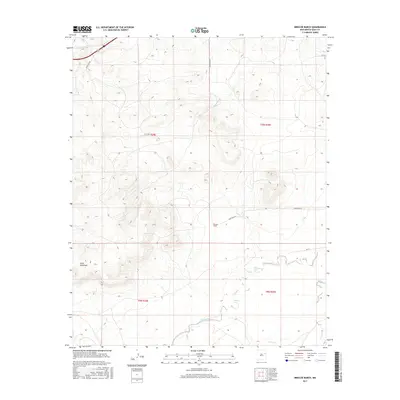
2017 Map of Briscoe Ranch
USGS Topo · Published 2017About this map
Briscoe Ranch serves as a focal point in this high-plains landscape of eastern New Mexico, where the terrain is defined by the prominent Mesa Quemado and a series of intermittent drainage systems. The hydrography of this Quay County region is marked by the winding paths of Blanca Cr, Bluewater Cr, and Charco Cr, which cut through the arid ranch lands. These seasonal watercourses are characteristic of the Llano Estacado's edges, where deep canyons and mesas create a complex topography. The local infrastructure relies on a grid of rural routes such as Quay Road At and Quay Road 55, reflecting the enduring pastoral and ranching economy of the early 21st century. The map provides a precise view of the Public Land Survey System boundaries, including the intersection of t10n r29e and t10n r30e, essential for tracing historical land ownership and grazing rights.
Find a feature on this map
16 named features on this map. Tap any name to fly to it.
Don’t see what you’re looking for? This feature index may not catch every label — zoom into the map to look around manually.
Map Details
Editions of this 2017 Briscoe Ranch Map
This is the sole edition of this map. No revisions or reprints were ever made.
Other maps of this area

1930 · Tucumcari
USGS Topo · 1:125,000

1954 · Tucumcari
USGS Topo · 1:250,000

1954 · Clovis
USGS Topo · 1:250,000

1958 · Clovis
USGS Topo · 1:250,000

1958 · Tucumcari
USGS Topo · 1:250,000

1967 · Liberty Mesa
USGS Topo · 1:24,000

1967 · Tucumcari
USGS Topo · 1:24,000
1968 · Quemado Hills
USGS Topo · 1:24,000

1968 · Bulldog Mesa
USGS Topo · 1:24,000
1968 · Cow Canyon
USGS Topo · 1:24,000