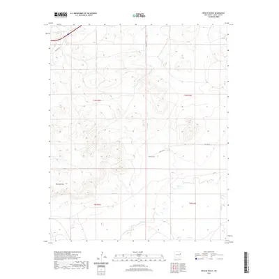
2020 Map of Briscoe Ranch
USGS Topo · Published 2020About this map
Briscoe Ranch serves as a central landmark in this high-desert landscape of eastern New Mexico, where the terrain is defined by a network of seasonal watercourses. The drainage patterns are dominated by Bluewater Cr and Charco Cr, which carve through the plains. The southern portion of the quadrangle is marked by the distinct elevation of Mesa Quemado, a prominent landform overlooking the surrounding basin. This area in Quay County remains primarily rural and ranch-oriented, with a grid of secondary routes such as Quay Road 55 and Quay Road At providing the only modern access. The map reveals the intricate natural topography of the Llano Estacado's edges, where Garcia Cr and Paris Cr transition through the arid environment.
Find a feature on this map
16 named features on this map. Tap any name to fly to it.
Don’t see what you’re looking for? This feature index may not catch every label — zoom into the map to look around manually.
Map Details
Editions of this 2020 Briscoe Ranch Map
This is the sole edition of this map. No revisions or reprints were ever made.
Other maps of this area

1930 · Tucumcari
USGS Topo · 1:125,000

1954 · Tucumcari
USGS Topo · 1:250,000

1954 · Clovis
USGS Topo · 1:250,000

1958 · Clovis
USGS Topo · 1:250,000

1958 · Tucumcari
USGS Topo · 1:250,000

1967 · Liberty Mesa
USGS Topo · 1:24,000

1967 · Tucumcari
USGS Topo · 1:24,000
1968 · Quemado Hills
USGS Topo · 1:24,000

1968 · Bulldog Mesa
USGS Topo · 1:24,000
1968 · Cow Canyon
USGS Topo · 1:24,000