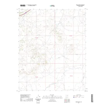
2023 Map of Briscoe Ranch
USGS Topo · Published 2023About this map
Mesa Quemado anchors the southwestern terrain of this high-plains landscape in Quay, New Mexico. The geography is defined by a network of drainage systems that carve through the mesa country, including the prominent Bluewater Creek which traverses the center of the sheet from west to east. To the north, Blanca Creek cuts across the corner near the Frontage Rd, while the southern reaches are marked by the winding paths of Charco Creek and Garcia Creek. The map illustrates a contemporary rural infrastructure where traditional land divisions of the Public Land Survey System meet a modern road network. Local transit is facilitated by routes such as Quay Road 55 and Q R 54, which provide access to the vast ranching tracts. This 2023 survey documents the enduring physical character of the Llano Estacado fringe, showing the relationship between ephemeral waterways like Paris Creek and the high tablelands.
Find a feature on this map
15 named features on this map. Tap any name to fly to it.
Don’t see what you’re looking for? This feature index may not catch every label — zoom into the map to look around manually.
Map Details
Editions of this 2023 Briscoe Ranch Map
This is the sole edition of this map. No revisions or reprints were ever made.
Other maps of this area

1930 · Tucumcari
USGS Topo · 1:125,000

1954 · Tucumcari
USGS Topo · 1:250,000

1954 · Clovis
USGS Topo · 1:250,000

1958 · Clovis
USGS Topo · 1:250,000

1958 · Tucumcari
USGS Topo · 1:250,000

1967 · Liberty Mesa
USGS Topo · 1:24,000

1967 · Tucumcari
USGS Topo · 1:24,000
1968 · Quemado Hills
USGS Topo · 1:24,000

1968 · Bulldog Mesa
USGS Topo · 1:24,000
1968 · Cow Canyon
USGS Topo · 1:24,000