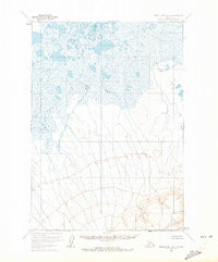
1963 Map of Bristol Bay A-1
USGS Topo · Published 1972About this map
Mud Creek dominates the low-lying northern expanse of this 1963 survey, carving a path through a landscape defined by expansive wetlands and unnamed lakes. The terrain transitions dramatically toward the south, rising into the foothills and peaks of the Aleutian Range. Surveyed by the Geological Survey and Bureau of Land Management using 1957 aerial photography, the map highlights localized high points including Alfred and Babs. The lack of roads or established trails on this sheet emphasizes the undeveloped character of this Bristol Bay region in the early 1960s, where movement was dictated by the drainage of the creek and the steepening contours of the southern highlands.
Find a feature on this map
3 named features on this map. Tap any name to fly to it.
Don’t see what you’re looking for? This feature index may not catch every label — zoom into the map to look around manually.
Map Details
Editions of this 1963 Bristol Bay A-1 Map
2 editions found
Other maps of this area

1943 · Ugashik
USGS Topo · 1:250,000

1948 · Ugashik
USGS Topo · 1:250,000

1949 · Ugashik
USGS Topo · 1:250,000

1951 · Bristol Bay
USGS Topo · 1:250,000

1951 · Sutwik Island
USGS Topo · 1:250,000

1963 · Ugashik B-6
USGS Topo · 1:63,360

1963 · Ugashik A-6
USGS Topo · 1:63,360

1963 · Bristol Bay
USGS Topo · 1:250,000
1963 · Bristol Bay A-2
USGS Topo · 1:63,360

1963 · Bristol Bay A-1
USGS Topo · 1:63,360