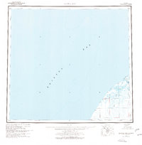
1963 Map of Bristol Bay
USGS Topo · Published 1977About this map
Bristol Bay dominates this mid-century coastal survey, capturing the complex shoreline of the Alaska Peninsula where the water meets a labyrinth of drainage and wetlands. The landscape is defined by the expansive Tidal Flat and the intricate movement of Mud Creek and the Cinder River. While much of the region is characterized by its hydrological features like Hook Lagoon, the map identifies several specific named sites such as Yucca, Sherry, Teck, and Quirt.
Find a feature on this map
27 named features on this map. Tap any name to fly to it.
Don’t see what you’re looking for? This feature index may not catch every label — zoom into the map to look around manually.
Map Details
Editions of this 1963 Bristol Bay Map
3 editions found

Other maps of this area

1943 · Ugashik
USGS Topo · 1:250,000

1945 · Nushagak Bay
USGS Topo · 1:250,000

1948 · Ugashik
USGS Topo · 1:250,000

1949 · Ugashik
USGS Topo · 1:250,000

1949 · Nushagak Bay
USGS Topo · 1:250,000

1951 · Bristol Bay
USGS Topo · 1:250,000

1951 · Sutwik Island
USGS Topo · 1:250,000

1951 · Hagemeister Island
USGS Topo · 1:250,000

1951 · Nushagak Bay
USGS Topo · 1:250,000

1951 · Ugashik C-6
USGS Topo · 1:63,360