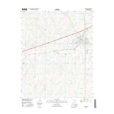
2016 Map of Bristow
USGS Topo · Published 2016About this map
Bristow serves as the primary urban center for this portion of Creek County, showing a dense street grid punctuated by Lake Massena and the Bristow City Cem. The surrounding landscape is defined by the extensive management of the Little Deep Fork Creek watershed, evidenced by numerous numbered flood control structures such as Little Deep Fork Cr Site 34 Reservoir and Little Deep Fork Cr Site 26 Reservoir. These reservoirs are integrated into a rural landscape where small settlements like Pulaski and Depew sit along the local road network. For genealogists, this map is particularly dense with burial sites, including the Poor Boy Cem, County Farm Cem, and Harjo Cem, reflecting the area's diverse family and institutional history. Aviation activity is centered at Jones Memorial Airport, positioned just east of the small community of Pulaski.
Find a feature on this map
68 named features on this map. Tap any name to fly to it.
Don’t see what you’re looking for? This feature index may not catch every label — zoom into the map to look around manually.
Map Details
Editions of this 2016 Bristow Map
This is the sole edition of this map. No revisions or reprints were ever made.
Other maps of this area

1901 · Nuyaka
USGS Topo · 1:125,000

1916 · Bristow
USGS Topo · 1:62,500

1929 · Stroud
USGS Topo · 1:62,500

1931 · Drumright
USGS Topo · 1:62,500

1932 · Stroud
USGS Topo · 1:62,500

1954 · Oklahoma City
USGS Topo · 1:250,000

1957 · Oklahoma City
USGS Topo · 1:250,000

1963 · Oklahoma City
USGS Topo · 1:250,000
1971 · Bellvue
USGS Topo · 1:24,000
1971 · Lake Heyburn
USGS Topo · 1:24,000