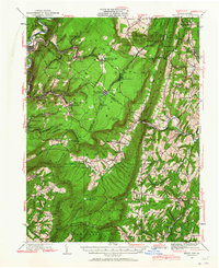
1930 Map of Broad Top
USGS Topo · Published 1965About this map
Broad Top Mountain dominates this landscape, serving as a hub for the region's industrial and coal-mining history. The complex geography of the area is defined by the narrow-gauge East Broad Top RR and the Huntingdon and Broad Top Mountain RR, which linked isolated communities like Robertsdale, Woodvale, and Broad Top City to wider markets. The map reveals a dense network of early 20th-century life, from the Garlicks Mine and Wells Tannery to numerous rural educational and spiritual centers such as the Eagle Foundry Ch and White Church.
Find a feature on this map
108 named features on this map. Tap any name to fly to it.
Don’t see what you’re looking for? This feature index may not catch every label — zoom into the map to look around manually.
Map Details
Editions of this 1930 Broad Top Map
2 editions found

Other maps of this area

1900 · Mercersburg
USGS Topo · 1:62,500

1900 · Everett
USGS Topo · 1:62,500

1901 · Huntingdon
USGS Topo · 1:62,500

1902 · Everett
USGS Topo · 1:62,500

1902 · Mercersburg
USGS Topo · 1:62,500

1902 · Hollidaysburg
USGS Topo · 1:62,500

1903 · Hollidaysburg
USGS Topo · 1:62,500

1904 · Huntingdon
USGS Topo · 1:62,500

1922 · Mt Union
USGS Topo · 1:48,000

1924 · Mt. Union
USGS Topo · 1:62,500