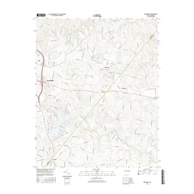
2016 Map of Broadway
USGS Topo · Published 2016About this map
The town of Broadway serves as a central hub in this modern survey of the North Carolina interior, where the Lee Co Harnett Co line bisects the landscape. The geography is defined by a dense network of local roads and water bodies, including City Water Works Lake and Lake Williams to the north, and the expansive residential developments surrounding Lake Trace to the southwest. The expansion of Sanford is visible on the western edge, while smaller communities like Seminole, Ryes, and Swann dot the rural sections. This 2016 data reveals how modern infrastructure, such as the Pumping Station Rd and the crossing of Upper Little River, continues to shape the region's development while maintaining the distinct character of individual ponds like James Hoover Johnson Pond and Watson Lake.
Find a feature on this map
129 named features on this map. Tap any name to fly to it.
Don’t see what you’re looking for? This feature index may not catch every label — zoom into the map to look around manually.
Map Details
Editions of this 2016 Broadway Map
This is the sole edition of this map. No revisions or reprints were ever made.
Other maps of this area

1953 · Raleigh
USGS Topo · 1:250,000

1954 · Raleigh
USGS Topo · 1:250,000

1956 · Anderson Creek
USGS Topo · 1:24,000

1957 · Murchisontown
USGS Topo · 1:24,000
1957 · Olivia
USGS Topo · 1:24,000

1970 · Colon
USGS Topo · 1:24,000

1970 · Moncure
USGS Topo · 1:24,000

1974 · Mamers
USGS Topo · 1:24,000
1974 · Cokesbury
USGS Topo · 1:24,000

1974 · Sanford
USGS Topo · 1:24,000