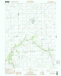
1998 Map of Brocton
USGS Topo · Published 2002About this map
The village of Brocton sits at a crossroads in the Illinois prairie, serving as a hub for the surrounding agricultural townships of Shiloh, Sargent, and East Oakland. This landscape is defined by the headwaters of the Embarras River and its tributaries like Catfish Creek, where family-named cemeteries and rural institutions are concentrated. Genealogists will find numerous burial grounds preserved here, including the Zimmerman Cem and Payne Cem, alongside the small settlements of Borton, Isabel, and Kings. The presence of several private airfields, such as the Williams Landing Strip and Ewing Landing Strip, alongside extensive drainage efforts like Ditch No 2, reflects the late 20th-century intersection of modern transportation and intensive prairie farming.
Find a feature on this map
29 named features on this map. Tap any name to fly to it.
Don’t see what you’re looking for? This feature index may not catch every label — zoom into the map to look around manually.
Map Details
Editions of this 1998 Brocton Map
This is the sole edition of this map. No revisions or reprints were ever made.
Other maps of this area

1936 · Oakland
USGS Topo · 1:48,000

1942 · Oakland
USGS Topo · 1:62,500

1946 · Kansas
USGS Topo · 1:62,500

1949 · Kansas
USGS Topo · 1:62,500

1953 · Indianapolis
USGS Topo · 1:250,000

1956 · Indianapolis
USGS Topo · 1:250,000

1956 · Newman
USGS Topo · 1:62,500

1956 · Villa Grove
USGS Topo · 1:62,500

1957 · Indianapolis
USGS Topo · 1:250,000

1958 · Decatur
USGS Topo · 1:250,000